San Marcos water damage guide
Flash Flood Alley in Central Texas, Explained
CTA (above the fold): Talk to a local flood-cleanup team (Primary button)
Meta title: Flash Flood Alley Explained | WDR San Marcos Meta description: Flash Flood Alley + limestone watersheds make San Marcos flood fast. Learn why the rivers rise so quickly & how to prepare. Read more.
Flash Flood Alley, central Texas explained in one line, is the band of country running roughly along the I-35 corridor where the ground sheds rain instead of soaking it up, and that is the whole reason San Marcos floods so fast. Rain that would disappear into sandy soil somewhere else runs straight off our limestone hills into the San Marcos and Blanco Rivers. The water arrives before you'd expect it to. Understanding the mechanism is the first step toward not being caught off guard by it.
What Is Flash Flood Alley and Why Does Central Texas Flood So Fast?
Flash Flood Alley is a region of Central Texas, running roughly along the I-35 corridor, where steep terrain and thin limestone soils shed rain quickly instead of absorbing it. Heavy rain runs straight into rivers like the San Marcos and Blanco, which can rise from calm to record levels within hours, making the area one of the most flash-flood-prone in the country.
It comes down to a few features stacking together:
- Limestone and clay ground that absorbs very little rain.
- The Balcones Escarpment, a steep fault line that funnels water downhill fast.
- Rainfall intensity, where short, hard downpours overwhelm the ground.
- Watershed convergence, where several drainages feed the same rivers near San Marcos.
Each one alone is manageable. Together, they turn an ordinary thunderstorm into a river on the move.
The Geology Behind It: Limestone and the Balcones Escarpment
Start with the rock. Most of the Hill Country around San Marcos sits on limestone, the same porous stone that feeds the Edwards Aquifer and the springs that make the San Marcos River so clear. Limestone is wonderful for spring-fed swimming. It is terrible at slowing down a storm. Where the surface is thin soil over hard rock, rain has nowhere to sink, so it sheets across the ground and gathers in the nearest creek within minutes.
Then add the slope. The Balcones Escarpment is the geologic seam where the flat coastal plain to the east meets the rising Hill Country to the west, and that change in elevation gives runoff somewhere to go in a hurry. Water that lands on the high ground does not linger. It races down the escarpment, picks up speed and volume along the way, and dumps into the river valleys below. Geology built a chute, and storms keep finding it.
There is a second wrinkle worth knowing. The hills around San Marcos hold very little soil, so during a long dry stretch the ground bakes hard and the few cracks that exist fill in. When the first heavy rain of the season finally lands, that baked surface can shed water almost as fast as a parking lot, which is why an early-spring storm after a dry winter sometimes produces a sharper rise than a wetter month would. The land does not ease into flood season. It snaps.
Why San Marcos Sits in the Worst of It
San Marcos sits near a meeting point. Several watersheds drain toward the same corridor here, so the San Marcos River and the Blanco River can both be loading up at once during a single regional storm. That convergence is why this city earns more flood attention than towns with just one river to watch.
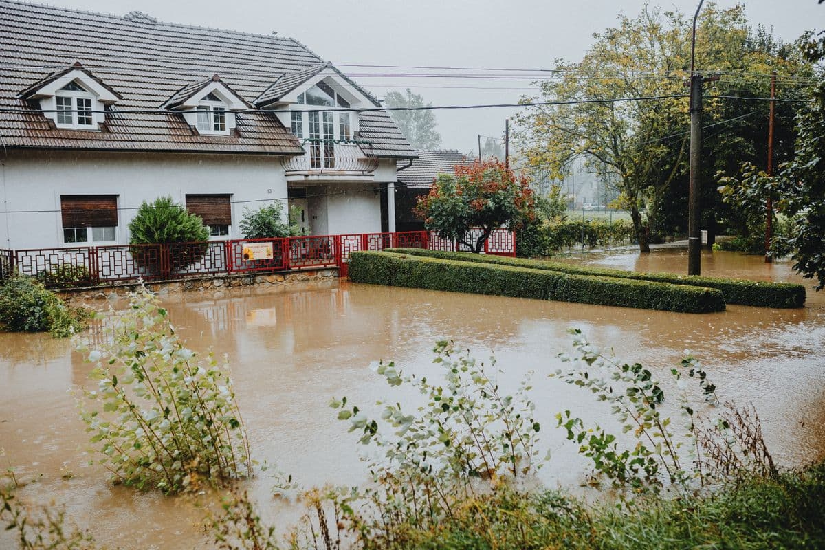
Geography ties the whole corridor together. Rain that falls near Wimberley swells the Blanco and heads downstream toward San Marcos, then continues past Martindale and on. That is why a homeowner downtown can be standing in dry weather while a wall of water is already building upstream, and why the river gauge above town matters more than the sky overhead. Up and down the I-35 line, from the edges of Austin through San Marcos and New Braunfels toward San Antonio, the same setup repeats. The 2015 Memorial Day flood made the convergence brutally clear when the Blanco crested at a record of about 40.21 feet, a level reached in hours, not days. When you live where the watersheds meet, you are downstream of weather you may never see.
Rainfall Intensity vs Total
Here is the part people get wrong. They watch the rain total and feel safe when the number sounds modest. The danger is not how much rain falls overall. It is how hard it falls in a short window over ground that cannot absorb it.
A storm that drops a few inches gently over a day might barely raise a creek elsewhere. The same total dropped in ninety minutes over Central Texas limestone runs almost entirely into the rivers, because the hard ground turns rainfall straight into runoff with very little soaking in, which is exactly why a flash flood can arrive faster than the rain ever felt like it should justify. Intensity is the variable that matters most here, and it is the one weather apps bury under a friendly daily forecast. A "small" storm in the wrong place, falling fast, is all it takes.
What This Means for Homeowners
Short warning windows. That is the practical reality of living in the Alley. When the rivers can rise within hours of a hard rain, the safe habit is to treat any flood watch upstream as your business, not just the watch over your own roof.
A few things follow from the geography. Know whether you sit in the river corridor or a low drainage, because elevation decides almost everything in a flash flood. Arrange flood insurance before the season, since rising-water flooding is excluded from standard homeowners policies and the math behind that is laid out in our guide to flood insurance vs homeowners insurance. Build a habit of preparation rather than panic, which is what our San Marcos flood season preparation checklist is built around.
Flooded fast? We respond fast: (512) 555-0143
If the water does get in, move quickly. River floodwater is contaminated Category 3 water, and the longer materials sit wet in our humid air, the more you lose to mold and rot. Fast, documented flood damage cleanup in San Marcos is what keeps a flash flood from becoming a months-long rebuild. For the local history that shows all of this playing out, the lessons from the 2015 San Marcos flood are worth a read. The geology will not change. How ready you are can.
Written by the Water Damage Restoration San Marcos team
Local water-damage restoration in San Marcos and Hays County. Our guidance follows the ANSI/IICRC S500 and S520 reference standards the industry plans around. Questions about your situation? Call (512) 555-0143, we answer 24/7.